
 2 hours ago
7
2 hours ago
7
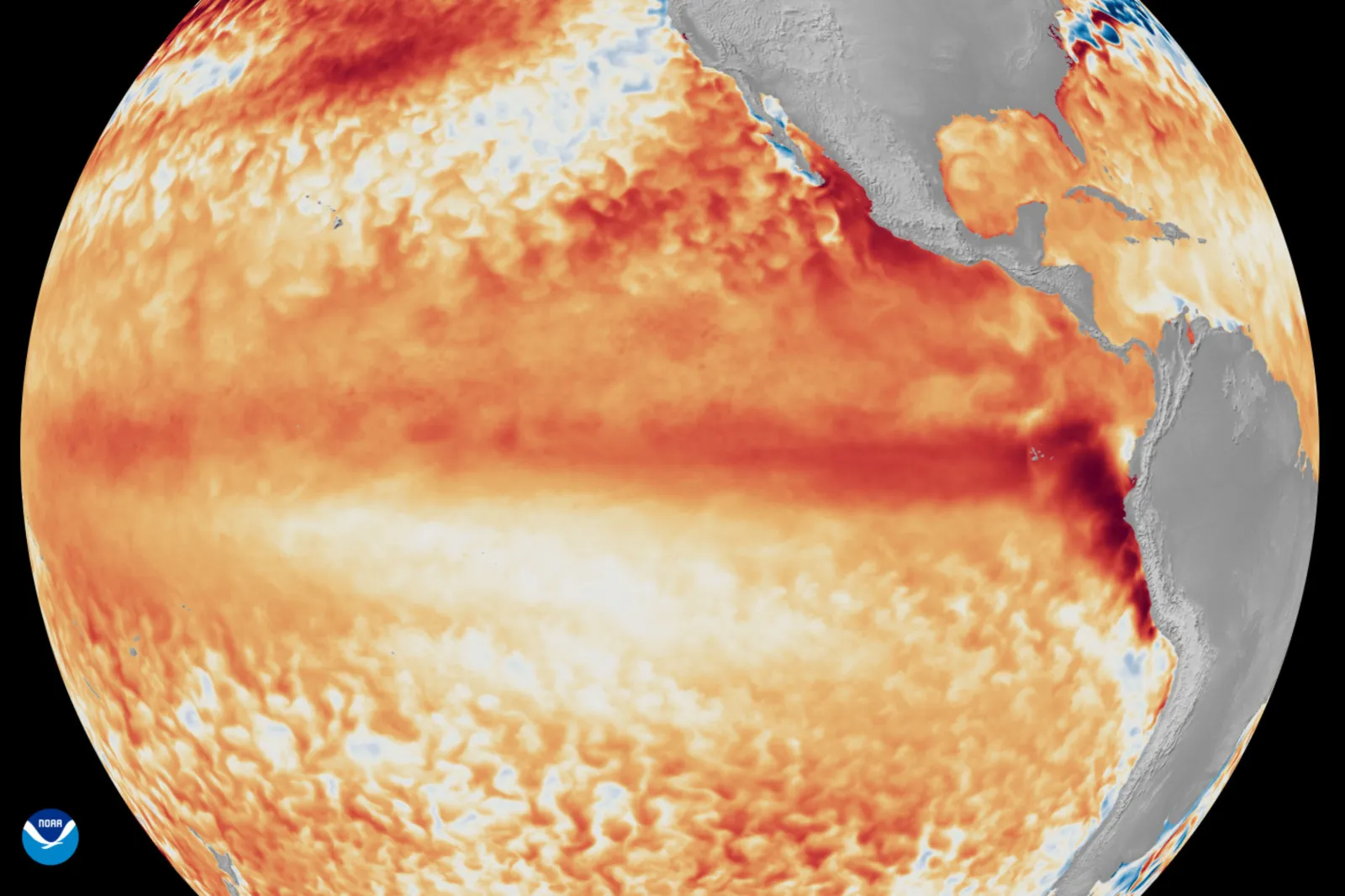
The El Niño climate pattern has formed in the tropical Pacific and could intensify into one of the strongest events in seven decades, Australia's weather bureau warned.
The country's Bureau of Meteorology said Tuesday that ocean and atmospheric conditions now confirm the arrival of El Niño, a climate phenomenon characterized by unusually warm sea-surface temperatures across the central and eastern Pacific Ocean.
Forecasters say the climate pattern is expected to intensify through the second half of 2026, with some models suggesting it could rank among the strongest recorded since 1950.
"Forecasts are pointing towards a strong to very strong El Niño event, based on the extent of warming in the central tropical Pacific," the Bureau of Meteorology said. "Around half of the models indicate this event could peak at levels among the highest observed since 1950."
The agency said that rainfall is likely to be below average across parts of southern and eastern Australia between July and September. Meanwhile, temperatures are expected to be above average in most areas, except parts of the north.
What It Means for Australia
Australia is vulnerable to El Niño because it is often associated with below-average rainfall and above-average temperatures across large parts of the country.
The bureau also said that El Niño can increase the chance of frosts and the risk of fires, placing additional stress on crops and livestock.
The country is one of the world's largest exporters of wheat, sugar and beef, making its agricultural performance important to international food markets.
Australia experienced an El Niño event from 2023 to 2024 that contributed to the driest three-month period ever recorded in parts of the country, the bureau said.
An earlier and particularly powerful event during 2015 and 2016 triggered widespread drought conditions and reduced grain and oilseed production, Reuters reported.
The Bureau of Meteorology said that El Niño events typically last six to 12 months but in some cases have lasted for up to two years. Forecasts suggest it will persist into 2027.
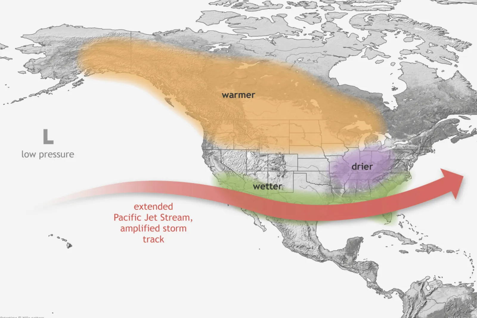
What El Niño Means for U.S.
For the United States, the biggest impacts of El Niño are typically felt during the winter months, when the warming of the Pacific Ocean alters the position of the jet stream and shifts major storm tracks.
One of the most common effects in the U.S. is wetter and stormier conditions for the southern portion of the country. During a typical El Niño winter, the Pacific jet stream shifts southward, increasing the likelihood of rain and mountain snow across parts of California, the Southwest, the Gulf Coast and portions of the Southeast.
While additional precipitation can help replenish reservoirs and ease drought conditions, it can also increase the risk of flooding and mudslides in vulnerable areas.
At the same time, much of the northern United States often experiences milder-than-average winter temperatures. The National Oceanic and Atmospheric Administration said that El Niño winters are frequently warmer across the northern states, reducing heating demand and the likelihood of prolonged cold outbreaks.
The weather pattern could also influence the 2026 Atlantic hurricane season. Stronger upper-level winds associated with El Niño tend to suppress hurricane and storm development in the Atlantic.